4 min
Tracking rain patterns will improve hurricane forecasting, UF researcher finds
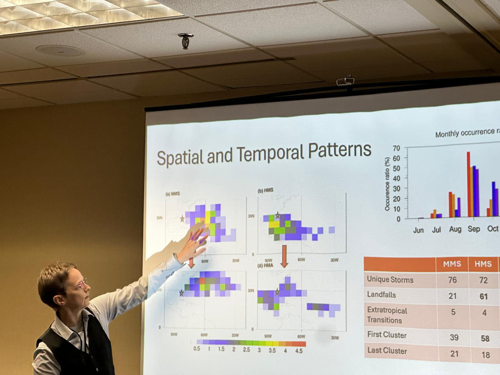
Studying the precipitation patterns in hurricanes may be key to predicting future storm patterns and their potential strength, a University of Florida researcher has found. Supported by a four-year, $212,000 grant from the National Science Foundation, Professor of Geography Corene Matyas, Ph.D. has identified the patterns of rain rates within storms and studied the moisture surrounding these storms. “We are hoping that, if we have a better prediction of moisture availability, that might help us forecast rain events with greater accuracy,” Matyas said. “The more we know about how storms develop, the more we can predict their path and magnitude.” The ideal stage for the perfect storm The potential for devastating high winds, storm surge and flooding poses an annual threat to Florida and its residents. With 1,350 miles of coastline and relatively flat geography that juts out to separate the warm waters of the southeast Atlantic and the Gulf, Florida creates the ideal stage for the perfect storm. Last year broke records with 18 named storms, including 11 hurricanes in the Atlantic basin and three major hurricanes making landfall along Florida’s coast. Early predictions are crucial to hurricane preparedness, allowing for increased response time and resource allocation, and hurricane modeling is essential for understanding these somewhat unpredictable storms. Advances in technology, data collection and the use of artificial intelligence in hurricane modeling have significantly impacted the ability to predict a storm’s path and strength more accurately. Artificial intelligence helps researchers understand hurricanes Matyas has completed two studies on this topic. The first study processed 12,000 images of rain rates from tropical storms and hurricanes in the Atlantic, using a machine learning algorithm called a convolutional autoencoder. Similar in use to image recognition software, the encoder broke the rain rate images down and simplified the patterns. Six main types, or clusters, of rainfall patterns for tropical cyclones were identified. At a presentation of the work to forecasters at the National Weather Service office in Jacksonville, the forecasters confirmed that one of the patterns matches what they typically see when late-season storms make landfall over Florida’s Gulf Coast. The second study used the autoencoder to process 4,600 images that represent the amount of moisture in the atmosphere extending 1,000 kilometers away from each hurricane. “We looked for commonalities in the patterns and found four dominant patterns of moisture that accompany Atlantic basin hurricanes,” Matyas said. “We found the biggest storms with the most moisture make the most landfalls, typically in the Caribbean and even in southern Florida. They also have a large moisture pool, giving them a bigger chance of heavy rainfall.” According to Matyas, three of the moisture patterns found in the second study were strikingly like those found in the earlier study that used fewer observations in a statistical analysis. With this use of AI, researchers can now recognize and understand these moisture patterns better, which can improve predictions about a storm’s intensity, its size and the amount of rainfall that will result from it. Early, accurate storm predictions allow Floridians time to prepare Rapid intensification – when, in a 24-hour period, a storm experiences a sudden drop in pressure and a dramatic increase in wind speed – creates much more of a challenge for forecasters. “We tend to boil down a hurricane to a set of coordinates which track the middle of a storm,” Matyas said. “And the fastest winds do focus there, but the moisture gets pulled from thousands of kilometers away and the system forces the moisture up. That moisture must go somewhere. So, the outer edges of the storm need to be understood more as well.” Matyas hopes these studies will help scientists classify rain patterns more accurately and consistently. Continued funding for research at public universities from federal agencies, such as the National Science Foundation and the National Oceanic and Atmospheric Administration, is essential for helping researchers develop tools to detect and predict severe weather events. Matyas is one of two UF faculty members among 18 national researchers named to the 2025 class of fellows by the American Association of Geographers. Matyas and UF Geography Department Chair Jane Southworth, Ph.D. were honored by the organization for their contributions in biogeography, geospatial analytics, soil science, community geography, climatology and other areas related to geography. “I look forward to this opportunity to contribute to the mission of the AAG in a more formal capacity, continuing to research how weather shapes our spaces and share knowledge of earth systems beyond the classroom and the written word to promote an inclusive society,” Matyas said.