

Robert Welch
Assistant Professor of Environmental Science Loyola Marymount University

Media
Biography
Outside of his active research, Robert has taught courses in structural geology, earth resources (e.g., global energy markets, the ins and outs of petroleum systems, and how to model hydrocarbon fields, and the impact of our energy portfolio on local and global ecosystems), and mentored students on independent research projects in the geosciences.
At LMU, Welch is excited to bring his enthusiasm for earthquake geology, the energy transition, and GIS to the forefront of his teaching and research. You can see him around campus this year teaching environmental statistical analysis & GIS, earth system science, and environmental management.
Education
Harvard University
Ph.D.
Earth and Planetary Sciences
2025
Harvard University
M.A.
Earth and Planetary Sciences
2023
Hamilton College
Bachelor of Arts
Geosciences
2020
Areas of Expertise
Industry Expertise
Affiliations
- Geologic Society of America
- Statewide California Earthquake Center
- Geoscience Education and Mentorship Support
Links
Research Focus
Kinematic Evolution of the Southern Canadian Rockies
2025-06-26
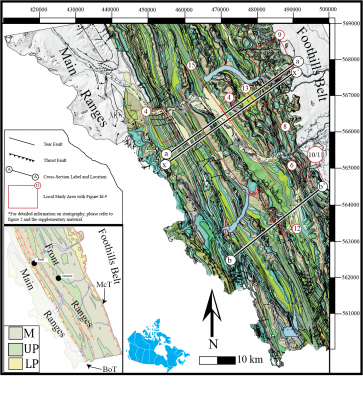
Using high-resolution remote sensing data along with field observations, we aim to develop a comprehensive three-dimensional geometric and kinematic description of the Front Ranges of the Southern Canadian Rockies. Our observations and analysis support many of the fundamental conclusions of previous work, namely the imbricate structural style and general break-forward progression of thrusting. However, our study suggests a pervasive, multi-modal distribution of bed dips separated by axial surfaces or hinge zones in the backlimbs of thrust sheets as opposed to the previous hypothesis of listric backlimb geometries.
Articles
Inferring Hypogene Karst at Depth from the Patterns of Non-Tectonic Syncline Networks in Eocene Limestones, Western Desert, Egypt
Frontiers in Earth Science, section Quaternary Science, Geomorphology and PaleoenvironmentTewksbury, Barbara J., Tarabees, Elhamy A., Welch, Robert M., Mehrtens, Charlotte J.
2021-06-29
Indirect indicators are critically important for recognizing hypogene karst that is too deep-seated to have explorable hypogene caves. We have suggested in previous publications that an extensive network of non-tectonic synclines in otherwise flat-lying Eocene limestone in Egypt might be such an indirect indicator. We proposed that synclines formed by sag of limestone layers overlying a zone of hypogene karst that today remains deep below the surface and suggested that hypogene speleogenesis resulted from ascending aggressive fluids associated with crustal extension and magmatism in Egypt during Red Sea Rift initiation. Without hypogene caves to explore, however, we were unable to provide compelling evidence for hypogene karst processes. By doubling our mapping area from 4,000 to 8,000 km2, a clear picture has emerged of patterns in the syncline network that provide compelling evidence for hypogene speleogenesis. Over this larger area, the network displays two distinct patterns: 1) synclines and ridges that outline polygons 700–2,000 m across, and 2) narrow N–S zones of synclines spaced 5–10 km apart, with WNW–ESE to NW–SE trending shallow synclines and ridges traversing the panels between N–S zones. The geometries suggest that the syncline network is controlled by two structural patterns in rocks underlying the limestones: 1) polygonal faults in underlying shales and 2) reactivated N–S, left-lateral basement faults that are largely blind at the current level of erosion. These structures served as conduits that conveyed fluids upward into the overlying Eocene limestones, triggering dissolution at depth and a pattern of sag above that was inherited from the nature and pattern of faults and fractures in rocks underlying the limestones. The unique patterns and characteristics of this network of synclines are applicable elsewhere as an indirect indicator of deep-seated hypogene karst. Our new data also strongly suggest that syncline formation spanned the time of crustal extension in Egypt associated with onset of Red Sea rifting ∼23–22 Ma. Endogenic CO2 associated with mantle-derived basaltic magmas was likely a significant component of fluids, perhaps involving highly aggressive supercritical CO2. Mantle-derived C and He in modern Egyptian oasis water suggest that hypogene speleogenesis may still be locally active.
Structure of the Southern Canadian Rocky Mountain Foreland and Western San Joaquin Basin Fold-and-Thrust Belts
Doctoral dissertation, Harvard UniversityWelch, Robert M.
2025-05-15
This thesis investigates the geometry and kinematic evolution of fold-and-thrust belts from tectonic to human timescales in the Front Ranges of the Southern Canadian Rocky Mountains and the South-Central San Joaquin Valley of California. Findings advance the field’s capabilities for developing internally consistent 2D and 3D models of both ancient and active fold and thrust belts and have important implications for earthquake hazards in California.
Structural Styles and Kinematic Evolution of the Front Ranges of the Canadian Rockies
GeosphereWelch, Robert M., Shaw, John H.
2025-06-26
We establish a comprehensive three-dimensional geometric and kinematic description of the Front Ranges in the Bow Valley–Kananaskis region of the Southern Canadian Rocky Mountains to rigorously evaluate and expand upon fundamental paradigms that define our understanding of thin-skinned fold- and- thrust belts. We employ a modern strike and dip data collection method based on high-resolution imagery and digital elevation models, verified by direct field observations, to analyze the structures and construct balanced and retrodeformable cross sections. This approach yields >10,000 new attitude measurements of bedding and faults that represent a more than tenfold increase in previously published maps of the region. These observations and our analysis support many of the fundamental conclusions of previous work, namely the imbricate structural style and general break-forward progression of thrusting. However, our analysis suggests a pervasive, multi-modal distribution of bed dips separated by axial surfaces or hinge zones in the backlimbs of thrust sheets as opposed to the previous hypothesis of listric backlimb geometries. Our data also show bedding and fault dips that are generally parallel.
These observations, coupled with the geologic map patterns, motivate refinements to the interpretation of structural styles, geometry, and faulting sequence of the region, including the presence of multiple regional basal detachments over an ~950 m zone. Through sequentially restoring our sections, we calculate a total shortening of 67 (±17%) km and derive a kinematic history of the Front Ranges that involves a complex, episodic sequence of thrusting. Overall, these insights, coupled with applying our semi-automated geologic data collection methods have applications for investigating exposed fold- and- thrust belts worldwide.