6 min
Expert Q and A: Understanding "Punch," The Baby Monkey That Captured The World's Heart
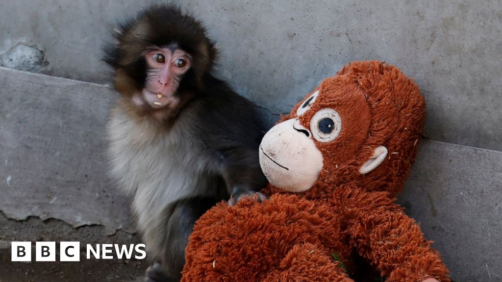
A tiny Japanese macaque named Punch has unexpectedly become one of the internet’s most talked-about animals. Born at a zoo in Japan and rejected by his mother shortly after birth, the young monkey was hand-raised by staff and given a stuffed toy for comfort—an image that quickly ricocheted across social media worldwide. Videos showing Punch tentatively approaching other macaques, sometimes being pushed away or corrected as he tried to socialize, struck an emotional chord. What began as a local zoo update rapidly turned into international headlines, with audiences from North America to Europe weighing in on what they saw as loneliness, resilience and the universal need for belonging. But experts say the story is more nuanced than a viral clip suggests. The interactions that many viewers interpreted as bullying are, in fact, typical components of macaque social development, part of how young primates learn boundaries, hierarchy and group norms. While Punch’s early maternal separation makes his integration more delicate, gradual acceptance into the troop is a positive sign. As internet users continue to share and comment, the moment has sparked broader conversations about animal emotion, anthropomorphism and the realities of wildlife behavior in managed care settings. Florida Tech's Catherine Talbot offered insight into the complexities of animal behavior. Catherine F. Talbot is an assistant professor in the School of Psychology at Florida Tech and co-director of the Animal Cognitive Research Center at Brevard Zoo. Her overarching research goal has been to study the ultimate (evolutionary) and proximate (behavioral, biological, and developmental) mechanisms underlying sociality. Q: Is it normal for mother macaques to abandon their babies, or is this an unusual occurrence? What circumstances can cause this to happen? It’s not necessarily normal, but also not that uncommon in primates, unfortunately. It’s more common in first time mothers that are inexperienced and sometimes lower ranking mothers. A number of factors can increase the likelihood of abandonment including stress on the mother and unfavorable conditions such as limited resources. Q: How does abandonment affect development in young macaques? Early maternal contact is critical for normal behavioral and emotional development. Infants rely on their mothers for nutrition, warmth, protection and learning how to navigate social dynamics. When infants do not have their mothers during critical developmental periods like infancy, in the short term, they tend to have elevated stress responses and difficulty with emotional regulation. In the long-term, it depends on whether the infant is able to form other types of attachment. In the worst-case scenario, they may have increased aggression, abnormal and/or self-injurious behavior, digestive issues and may lack social skills. But primates are resilient, and with social support and gradual integration into a troop, Punch can form new attachments, learn socially appropriate behavior and ultimately live a fairly normal monkey life. Q: Is it obvious to the rest of the troop when a young macaque has no mother? How does this affect integration? Japanese macaques have really complex social worlds, so they are really in tune with the relationships they have with one another and recognize the relationships between other individuals. That can certainly make it more difficult for Punch to be accepted back into the troop – he needs to find some friends and possibly even a surrogate parent. With social support, he should be able to recover from the absence of a mother. It’s really great to see that the care staff stepped in to support Punch as he begins to recovery from the stress of this experience. It’s even more important that Punch is around other monkeys of the same species so that he can continue to learn from them and respond appropriately to social communication cues. I’m thrilled to see that Punch is now making friends. Q: Punch is obviously attached to his stuffed orangutan. We can understand how this happens from our own human experience, but can you explain, on a biological level, how he bonded with this stuffed animal? Primates, including humans, are neurobiologically wired to form strong social bonds with a caregiver very early in life. In many primate species, infants are born highly dependent on their mother. Punch’s attachment to the stuffed orangutan reflects this need for attachment. That physical touch – warmth, softness, graspable limbs, a stable physical presence – can partially activate those same calming biological pathways, including the release of oxytocin which regulates stress and promotes feelings of safety. Without activation in those pathways, Punch would likely experience stronger feelings of separation or loneliness and ultimately social withdrawal. These biological pathways are crucial to proper social and emotional development of any primate species. Any way we can help mitigate those effects for Punch is crucial for successful integration back into his troop. Q: How does sociality among Japanese macaques compare to that of similar species? Japanese macaques live in large multi-male, multi-female social groups that can range from roughly 50 to 150 individuals. Like many macaques species, they form stable, female-bonded societies. Females remain in their natal group (or the group they were born into) for life, inherit their mother’s rank, and form strong kin- based alliances whereas males emigrate to a new group at adolescence. Their societies are organized around matrilines or extended female family lines in which rank is very important. They have strong dominance hierarchies and generally high levels of aggression, but levels of aggression and tolerance can vary a good amount from group to group. Entire matrilines can outrank others, which dictates access to food, grooming partners, and coalitions. Within a single troop, you often see multiple matrilines with long-standing dominance competitions. I sometimes compare it to a Romeo and Juliet-style Montague and Capulet dynamic, where beneath the surface of daily grooming and foraging is a complex political landscape structured by kinship and status. Q: What behaviors can Punch expect from the rest of the monkeys as he continues to integrate with the troop? What behaviors can the troop expect to see from him? As Punch continues to integrate into his troop, I would expect to see some social testing by other members of the group to see how Punch responds- they may use mild aggression like open mouth threats or direct stares (which arethreatening is macaques), brief chases, and displacement from resources like food/resting spots. These will help clarify Punch’s rank and help form and maintain a stable hierarchy. Therefore, I hope to see Punch make at least a few strong social bonds (friends), to help defend him against more intense aggression. As long as he makes a few friends, he should begin to receive more affiliative behavior. Integration is usually gradual as these bonds form and strengthen and these skills develop. I would expect to see more play and grooming with conspecifics and less reliance on his stuffed orangutan as real social bonds start to form. Grooming is especially important for forming and maintaining social bonds and there are already videos showing Punch receiving some grooming from older monkeys, which bodes well for him. He also needs to respond in socially appropriate ways, like grooming others and showing submission to higher ranking individuals. Essentially, he needs to understand and follow the rules of Japanese macaque society. Q: What message do you have as people continue to root for Punch? It's uplifting to see how much support Punch has gained across the world. And while Punch is clearly adorable and so vulnerable that you just want to love him and give him (or other monkeys like him) a home, it’s important to remember that more than anything else, he needs to live with other monkeys so that he can live a life that is true to his species and nature. Unfortunately, many people still have monkeys as pets. The illegal wildlife trade is a multi-billion-dollar industry, ranking as the fourth largest illegal trade after drugs, arms, and human trafficking. Within the United States, it is estimated that there are more than 15,000 nonhuman primates living in unsuitable conditions. Primates are intelligent, sentient beings that need complex communities and relationships to thrive. There currently is no federal legislation that protects primates from private ownership, but the Captive Primate Safety Act (H.R.3199/ S.1594) has been proposed to prohibit the private possession of nonhuman primates and the sale or transportation of nonhuman primates for the wild pet trade. If you're interested in connecting with Catherine and learning more about animal behavior, let us help. Contact Adam Lowenstein, Assistant Vice President for External Affairs at Florida Institute of Technology, at adam@fit.edu to arrange an interview today.