Experts Matter. Find Yours.
Connect for media, speaking, professional opportunities & more.

Rip Current Simulations Save Lives
Jase Bernhardt, Hofstra University associate professor of geology, environment, and sustainability and director of meteorology, was referenced in a USA Today article about simulations that teach the public about rip current safety. For years, Dr. Bernhardt has been leading research that offers a virtual reality simulation of being caught in a rip current and teaches ways swimmers can navigate to safety. The development of this technology is supported in part by New York Sea Grant (NYSG).


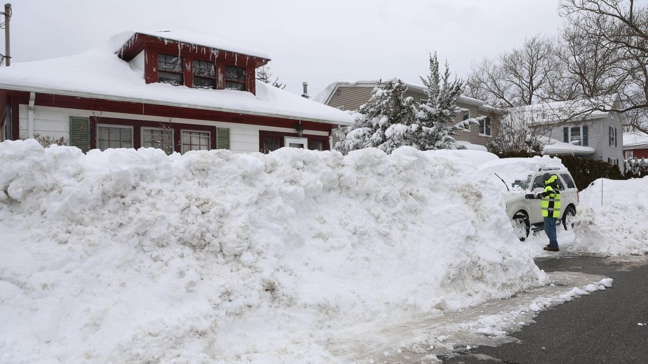
Blizzard of ’26 – One for the History Books
“The blizzard of ‘26 will be remembered in meteorology circles,” Dr. Jase Bernhardt told Newsday about the historic storm this week that dropped approximately 30 inches of snow on parts of Long Island. The Hofstra University associate professor of geology, environment, and sustainability and director of meteorology explained the blizzard hit what’s known as the “70/40 benchmark." That’s 40 degrees north latitude and 70 degrees west longitude, geographic coordinates for a spot over the Atlantic Ocean: “That’s the sweet spot,” said Dr. Bernhardt. “Say it tracks 50 miles south and east, that means the heaviest snow shifts farther away. If it tracks closer, oftentimes, it’s bringing in warm air closer to the center [of the storm], and if it tracks too close, it might yield heavy precipitation, but it’s going to be too warm for all snow.”
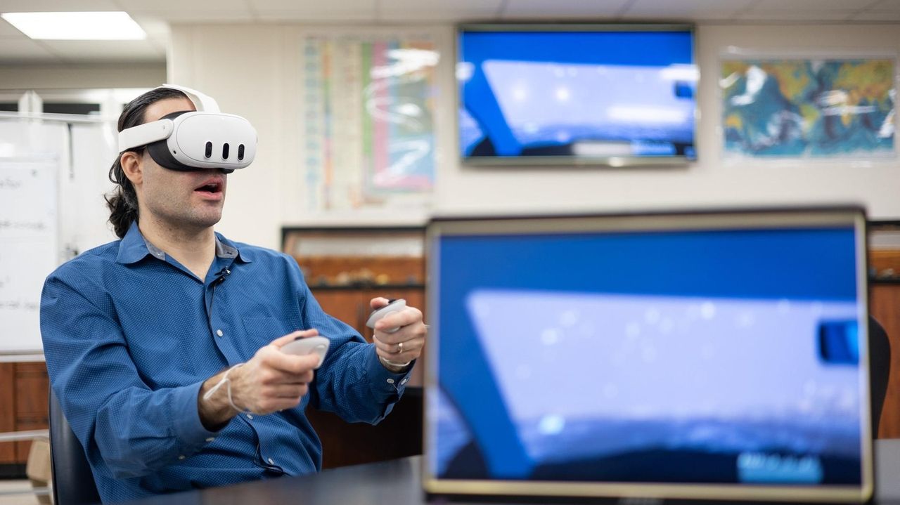
VR Teaches the Danger of “Short-Fuse” Weather Events
Dr. Jase Bernhardt, associate professor of geology, environment, and sustainability and director of Hofstra University’s meteorology program, was interviewed by Newsday about the use of virtual reality technology to teach the public about the danger of driving in a snow squall.

Teaching Driving Safety During a Snow Squall
Dr. Jase Bernhardt, associate professor of geology, environment, and sustainability and director of Hofstra University’s meteorology program, was interviewed by Fox Weather about a virtual reality tool he developed that simulates the danger of driving in a snow squall.
Forensic Meteorology in Insurance: Bridging Weather Science, Claims, and Liability
When severe weather strikes, the insurance industry is not only contending with damage and loss, but also with the question: Did this storm event actually occur, and did it trigger the risk covered under policy terms? J.S. Held's forensic meteorologist Daniel Schreiber authored an article explaining how Certified Consulting Meteorologists substantiate (or refute) storm-event claims by reconstructing what the weather actually did at a loss location. In his article “Forensic Meteorology in Insurance: How Do Certified Consulting Meteorologists Help with Storm Damage Claims & Disputes?” Schreiber illustrates how the overlap of a valid insurance policy, a damaging event, and a verified storm forms the core of many disputed claims. Dan Schreiber is a Certified Consulting Meteorologist with over ten years of experience in military, aviation, and severe weather operations. Mr. Schreiber has provided consulting and expert services for both plaintiff and defense law firms and insurance adjusters, appraisers, umpires, and policyholders throughout North America. He has been consulted and/or retained as an expert in over 850 matters and has testified in both depositions and during trials in state and federal courts. View his profile here Why This Matters In an era of escalating extreme weather events and heightened exposure for insurers, the science of forensic meteorology — the application of certified weather expertise to claims investigation and litigation — is becoming indispensable. Professional meteorology, as it relates to insurance claims handling and the litigation process, is becoming increasingly recognized, and the employment of meteorologists within the insurance industry is growing. Schedule an interview with Daniel Schreiber to learn more about how forensic meteorologists can help with insurance claims and disputes by clicking on his icon below.


Why College Students Are Storming Fields More Often
In his most recent Forbes article, Dr. Marshall Shepherd takes a scientific look at why college students and fans storm football fields, blending insights from psychology, meteorology, and social dynamics. He explains that field-storming is not simply a burst of emotion—it’s a predictable outcome of collective excitement and shared identity. After an unexpected win or a high-stakes rivalry game, thousands of people simultaneously experience what psychologists call “emotional contagion,” amplifying feelings of unity and celebration. This shared surge, combined with environmental cues like stadium acoustics and crowd density, transforms the act into what Shepherd calls a form of “social weather event.” “Storming the field isn’t chaos—it’s choreography fueled by emotion and crowd physics.” Shepherd also examines the logistical and safety implications. He notes that while universities often celebrate these spontaneous displays of school pride, they carry risks ranging from crowd injuries to property damage. Yet, institutions are reluctant to ban them outright because these moments reinforce fan loyalty and media attention. Shepherd suggests that the solution lies in better understanding crowd behavior: designing stadiums with safe egress routes, training security teams to manage surges, and anticipating emotional tipping points rather than reacting afterward. “Understanding the science behind fan behavior lets us manage energy, not suppress it.” Ultimately, Shepherd’s piece reframes field-storming as a fascinating mix of culture and physics—where joy, identity, and momentum collide. He urges universities to see these moments not as mere rule-breaking but as opportunities to study human behavior in motion, and to design environments that celebrate passion without compromising safety. Dr. J. Marshall Shepherd is a leading international weather-climate expert and is the Georgia Athletic Association Distinguished Professor of Geography and Atmospheric Sciences at the University of Georgia. Dr. Shepherd was the 2013 President of American Meteorological Society (AMS), the nation’s largest and oldest professional/science society in the atmospheric and related sciences. View his profile here Dr. J. Marshall Shepherd is available to speak with the media about this interesting topic - simply click on his icon now to arrange an interview today.


Experts in the Media: Hurricane Season Isn’t Shutdown. A Busy Week Looms For Meteorologists
When you think hurricane season is winding down, think again. Just as many people begin to relax after a stretch of calm weather, the atmosphere often has other plans. Meteorologists are warning that even as we head deeper into October, the tropics are far from done stirring. The “off-season,” as Dr. Marshall Shepherd puts it, can be one of the most deceptive times of year—when attention fades but nature remains restless. Dr. J. Marshall Shepherd is a leading international weather-climate expert and is the Georgia Athletic Association Distinguished Professor of Geography and Atmospheric Sciences at the University of Georgia. Dr. Shepherd was the 2013 President of American Meteorological Society (AMS), the nation’s largest and oldest professional/science society in the atmospheric and related sciences. View his profile here In his recent Forbes article, Shepherd, a leading atmospheric scientist and former president of the American Meteorological Society, reminds readers that the Atlantic hurricane season doesn’t have an on-off switch. While it may appear to be slowing, meteorologists are bracing for a busy week ahead as multiple weather systems continue to develop. He explains that this year’s pattern demonstrates how tropical activity often ebbs and flows, and a lull in storms doesn’t mean the threat has passed. Shepherd highlights how experts are closely watching sea-surface temperatures, wind shear, and atmospheric moisture—factors that can quickly transform calm seas into cyclone breeding grounds. Despite the calendar inching toward November, he warns that conditions remain ripe for sudden storm formation. Ultimately, Shepherd’s message is one of preparedness and respect for nature’s unpredictability. Even when the radar looks clear, the tropics can still surprise us. His call to stay alert is a timely reminder that meteorology is not about predicting the past—it’s about anticipating the next twist in the weather’s unfolding story. Dr. J. Marshall Shepherd is a leading international weather-climate expert and is the Georgia Athletic Association Distinguished Professor of Geography and Atmospheric Sciences at the University of Georgia. He's available to speak with the media about this topic - simply click on his icon now to arrange an interview today.
By Steven Lazarus Like many coastal regions, Florida’s Space Coast faces significant climate resilience challenges and risks. According to the National Oceanic and Atmospheric Administration (NOAA), Florida has over 8,000 miles of shoreline, more than any other state in the contiguous U.S. In addition, the 2020 census indicates that that there are 21 million Florida residents, 75-80% of which live in coastal counties. This makes our state particularly vulnerable to rising sea levels, which are directly responsible for a host of coastal impacts, such as saltwater intrusion, sunny-day (high-tide) flooding, worsening surge, etc. There is growing evidence that storms are becoming wetter as the atmosphere warms— increasing the threat associated with compound flooding, which involves the combined effects of storm surge, rainfall, tides and river flow. Inland flooding events are also increasing due to overdevelopment, heavy precipitation and aging and/or inadequate infrastructure. The economic ramifications of these problems are quite evident, as area residents are confronted with the rising costs of their homeowners and flood insurance policies. As the principal investigator on a recently funded Department of Energy grant, Space Coast ReSCUE (Resilience Solutions for Climate, Urbanization, and Environment), I am working with Argonne National Laboratory, Florida Tech colleagues, community organizations and local government to improve our climate resilience in East Central Florida. It is remarkable that, despite its importance for risk management, urban planning and evaluating the environmental impacts of runoff, official data regarding local flooding is virtually nonexistent! Working alongside a local nonprofit, we have installed 10 automated weather stations and manual rain gauges in what was previously a “data desert” east of the Florida Tech campus: one at Stone Magnet Middle School and others at local homes. “We think that a ‘best methods’ approach is proactive, informed and cost-effective. The foundation of good decision-making, assessment and planning is built on data (model and observations), which are critical to adequately addressing the impact of climate on our communities.” – steven lazarus, meteorology professor, ocean engineering and marine sciences Data from these stations are available, in real-time, from two national networks: CoCoRaHS and Weather Underground. The citizen science initiative involving the rain gauge measurements is designed to document flooding in a neighborhood with limited resources. In addition to helping residents make informed choices, these data will also provide a means by which we can evaluate our flood models that will be used to create highly detailed flood maps of the neighborhood. We are working with two historic extreme-precipitation events: Hurricane Irma (2017) and Tropical Storm Fay (2008)—both of which produced excessive flooding in the area. What might the local flooding look like, in the future, as storms become wetter? To find out, we plan to simulate these two storms in both present-day and future climate conditions. What will heat stress, a combination of temperature and humidity, feel like in the future? What impact will this have on energy consumption? The station data will also be used develop and test building energy-efficiency tools designed to help the community identify affordable ways to reduce energy consumption, as well as to produce high-precision urban heat island (heat stress) maps that account for the impact of individual buildings. The heat island and building energy modeling will be complemented by a drone equipped with an infrared camera, which will provide an observation baseline. We think that a “best methods” approach is proactive, informed and cost-effective. The foundation of good decision-making, assessment and planning is built on data (model and observations), which are critical to adequately addressing the impact of climate on our communities.


Five storms predicted in the Gulf this season, says CoMET Lab
A composite of 500-mb temperatures from the seasonal weather model simulations used to generate the forecast. (The green outline shows the area averaged across for the Gulf of America.) The "-4.85C" is the temperature over the Gulf that ultimately fed into the equation to yield the prediction of 5 named storms. This hurricane season, five named storms are predicted for the Gulf, according to LSU’s Coastal Meteorology, or CoMET Lab, which issues a Gulf of America-specific forecast. Five represents a slight uptick in storm activity, said Paul Miller, the head of the CoMET Lab. Miller is an associate professor in the Department of Oceanography & Coastal Sciences, or DOCS. The seasonal average for the area is 3.7 storms. This forecast in elevated hurricane activity is in alignment with predictions for the Atlantic Ocean as a whole – NOAA has called for between 13 and 19 storms in the basin between the beginning of June and the end of November. CoMET Lab’s forecast works a little differently than the Atlantic-based predictions. Those models generally focus on ocean temperatures, among other factors. CoMET’s forecast, which was initially developed with Geography and Anthropology Professor Jill Trepanier, instead focuses on average atmospheric temperatures around the Gulf, approximately six kilometers, or four miles, above the ground. Miller said he and Trepanier considered a range of potential predictive factors when they first developed the forecast in 2021, before settling on atmospheric temperature. “What our data shows is that the warmer the temperature is, the fewer storms there should be. The colder the temperature is, the more storms,” Miller said. This link to cooler temperatures at high atmospheric altitudes may appear counterintuitive, but, he said, “think of a hot air balloon. It only works if it’s hotter than the air around it… If you go four miles above the ground, that tells you if you have a reservoir of potential buoyancy. If the air can make it to that altitude, it’s got a better chance of continuing to rise and forming [a storm].” Normally CoMET’s forecast utilizes temperatures throughout the month of May, but due to recent changes in data available from NOAA, Miller noted that this year’s forecast is based on readings from the last two weeks of the month. Article originally posted here.

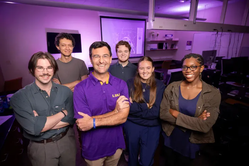
LSU Lab Helps Louisiana Prepare for Hurricanes, Drought, even Saharan Dust
Any hurricane that forms in the Gulf of America is a direct threat to Louisiana and its neighboring states. But most seasonal forecasts focus on the entire North Atlantic Basin, including areas where storms may never come close to any land, much less the U.S. Gulf Coast. A Gulf-specific forecast developed at LSU’s Coastal Meteorology (COMET) Lab addresses that issue by providing storm information specifically geared toward the Gulf region. The lab is run by Paul Miller, an associate professor at LSU who founded it in 2019. “We decided that a Gulf-specific forecast could help state officials and Gulf-area residents better understand how active the upcoming season might be in their part of the Atlantic,” said Miller, who teaches in the Department of Oceanography & Coastal Sciences in the College of the Coast & Environment. Miller said the LSU-Velocity Risk Gulf Hurricane Outlook is one example of how the COMET Lab delivers real benefits to Louisiana. “A lot of forecasts tend to align with each other each year. But ours works a lot differently than some of the other forecasts that are geared towards larger areas of the ocean,” he said. “We’re not the world’s leading hurricane research lab—and we don’t try to be. Instead, we prioritize meeting the largest research gaps relevant to Louisiana residents, spanning a wide variety of weather hazards. “We want to make sure Louisianans experience a clear return-on-investment from our lab’s activities.” Ways the lab supports the state also include: Helping forecast storm surge in real time and informing the decision on when to close flood barriers before a tropical system hits land. Developing rainfall models to support flood prevention efforts. Studying weather patterns that cause drought and low coastal water levels that can lead to marsh loss during dry spells on the Gulf Coast. Saharan Dust Research One area of study that incorporates both air quality and tropical weather is the lab’s research on Saharan dust clouds, which are blown across the Atlantic in an air mass called the Saharan Air Layer, or SAL. “So, this sort of far-off distant concept of Saharan dust is actually something that is kind of important to folks here in Louisiana,” Miller said. This dust can shut down thunderstorm activity in the U.S. Caribbean territories, a key area of research in the COMET Lab, and cause respiratory problems when it reaches the Southeast U.S. The SAL can also suppress hurricane activity in the Atlantic. “Our lab just launched a new project with the Office of Naval Research to determine how dust-dimmed sunlight can affect ocean temperatures in the Atlantic’s most active hurricane breeding grounds,” Miller said. Read the full story here.